hankyoreh
Links to other country sites 다른 나라 사이트 링크
[Korea travels] Earth, wind, water and sunsets: Ansan’s coastal islands have a little of everything
The city of Ansan in Gyeonggi Province encompasses islands, the sea, and mountains.
Among its islands are the three inhabited islands of Daebu — which comprises the cluster of Daebu, Seongam, Bul and Tan islands — Pung and Yuk, and 10 deserted islands including Nue Island and Halmi Island.
The largest of Ansan’s islands, Daebu Island (40.34km²) is a prime travel destination near Seoul boasting incredible scenery as well as a view of mudflats during low tide as well as the sunset. It’s a great place for socially distanced travel to escape the monotony of the everyday.
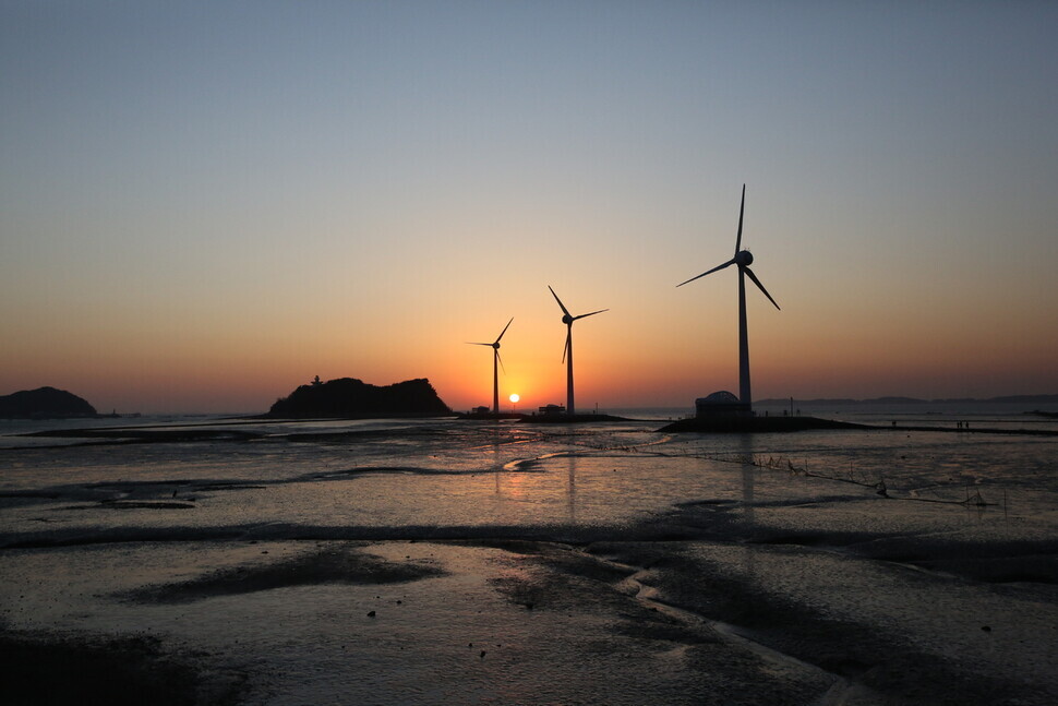
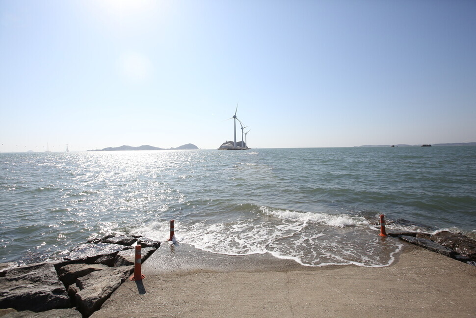
On Feb. 27, I headed to Tando Port on Daebu Island, Ansan. Thanks to social media, the port has become a popular spot for travelers to take pictures of the sunset as the sun disappears beyond the horizon behind three towering wind power generators (known as the “triplets”) and the deserted island of Nue. Travelers can also make special memories in Ansan by walking along the sea route that appears twice a day during low tide.
After the full tide at 2 pm, I could see the route emerging as the sea retreated: a 1-kilometer cement road showing me the way to Nue Island from Tando Port. The walkable path appears and disappears with the ebb and flow of the Yellow Sea.
This means that the ocean landscape changes between high and low tide. Those wishing to walk along this road need to time their visit to the tide times, which change from one day to the next.
The road is walkable during low tide, when the waters have receded. But when the tide comes in, travelers heading toward the island risk getting stranded. Tide times can be found on the Daebu Island website (daebudo.com) or the website Bada Time (badatime.com).
Walking along the pathway when the waters have receded, visitors can see the tidal flats sprawling on either side. This is a setting for all sorts of tidal flat activities, including oyster picking and clam digging.
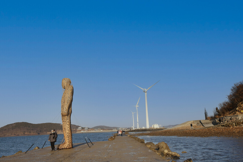
After a roughly 20-minute walk past the “triplets” toward Nue Island, I could see a large sculpture measuring 7 meters in height. This sculpture in the shape of a person was built with bamboo and rebar.
Next to the sculpture was a sign that read “K-Portrait” (created by Choi Pyung-gon, 2021). The work is a representation of people living in the contemporary era.
It was put in place as part of a public art program by the Ansan Cultural Foundation that combines art with nature. This project continues until March 27.
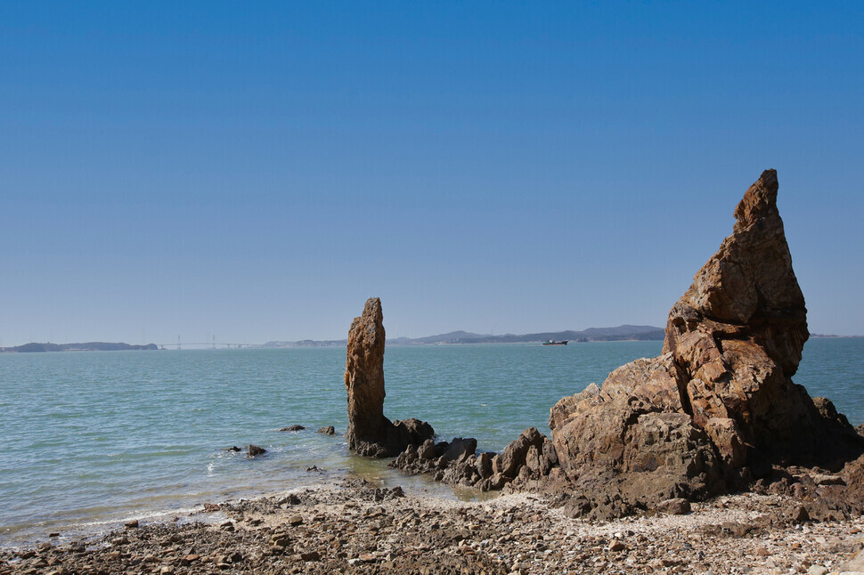
I walked along the sea route until I reached Nue. In Korean, the name literally means “silkworm” — so given because the island resembles a silkworm when seen from a distance. While there are no people living on the rocky island, it has its own life growing on it: the island is dominated by green pines, grass and scrub.
All around the island, the evidence of past visits could be seen. Several stacked stones — known in Korean as “doltap” — had been put in place by visitors making wishes on them.
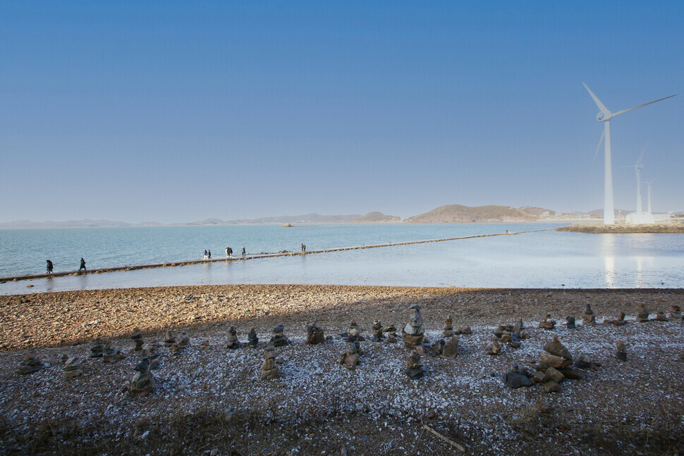
A walk around Nue’s full circumference is not especially taxing. It’s a small island with an area of 0.4 square kilometers, which means you can see all of it in a 30-minute walk.
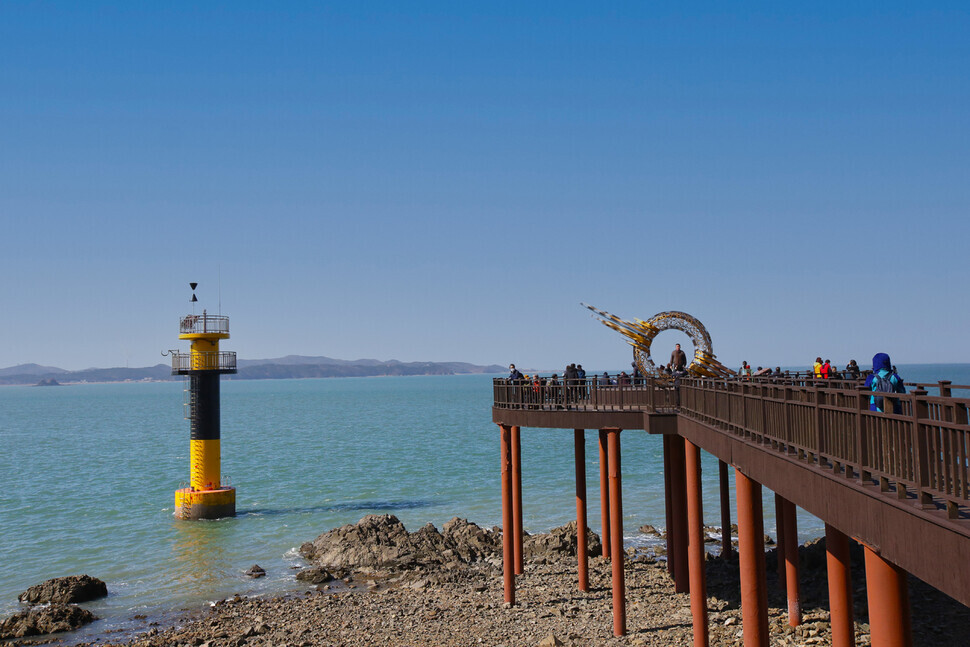
One site worth seeing on the island is the lighthouse observatory at its summit. The exhibits on display there include various images and archival materials related to Nue’s natural environment, lighthouses, and the sea, along with models of lighthouses in Korea and overseas.
From the observatory on the third floor, visitors can take in the landscape of surrounding islands — including Daebu Island, Jebu Island, and Tan Island — and their fishing villages. On the fourth floor is a beacon, put in place to help ocean vessels travel safely. Operating hours vary with the tide times; admission is free.
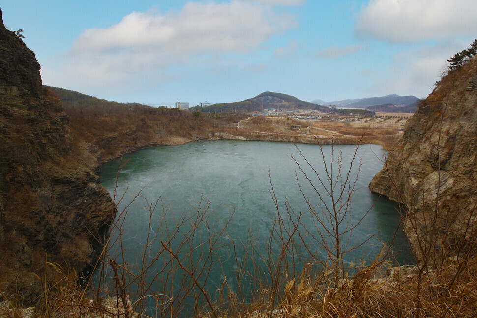
Five minutes by car from the Tan Island harbor, visitors can see an unusual landscape: the Daebu Mine Sedimentary Rocks (Gyeonggi Provincial Monument No. 194), which includes a lake and the titular rock layer.
In the past, this was a rock quarry. In 1999, dinosaur tracks and 23 plant and animal fossils were discovered during the extraction of rocks. Some of the fossils are on display today at the Ansan Fishing Village Folk Museum; three particularly well-preserved specimens have been left in place at the layer.
Based on dating of the sedimentary particles deposited by the eruption of a volcano, the sedimentary rock layer is estimated to have been formed around 70 million years ago — after the Mesozoic Era, when dinosaurs thrived.
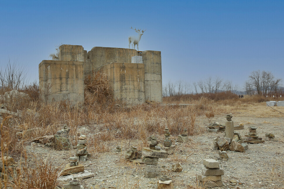
The area had not yet attracted many visitors, and it felt quite desolate. The concrete structures once used for the quarry remained in place, surrounded by the odd doltap erected by visitors.
The Daebu Mine Sedimentary Rocks have a path that allows visitors to walk around its perimeter. I took the path up to the top of a low hill, where I could see the beautiful landscape of the Yellow Sea.
The hill had two observation platforms at the top. From one of them, I could look out on the lake and the vast cliff face of the mine’s rock layer. From the other, I could see the vast expanse of the Yellow Sea, the wind power generators, the islands of Nue and Jebu, Jeongok Port, and the fishing village. It’s a hidden observation site with few visitors.
For those looking to taste more of Daebu Island’s hidden charms, I recommend walking along the Daebu Haesol Path. It consists of seven courses in all, with a total length of 74 km. They connect with Gubong Island, the Daebunam neighborhood, Seongam Island, the Tan Island harbor, and on to the Daesong complex.
It’s an opportunity to walk the full perimeter of Daebu Island along the coast. The courses include a pine tree route, a salt pond route, a sunset route, a sea route, a tidal flat route, a reed route, a grapevine route, and a rural route.
The first course in particular is renowned for its scenery, offering sights and activities at the “Ant’s Waist” (gaemiheori) arch bridge, the setting sun observatory, and the Jonghyeon fishing experience tourism village. The course winds around Bungmang Hill and Gubong Island, traveling over the arch bridge to the setting sun observatory.
“Every course on the Daebu Haesol Path has a different landscape with its hills, sea, and villages,” explained Ahn Su-yeong, a cultural tourism guide for the city of Ansan.
“For those who would like to see fishing village landscapes, I recommend the fourth course, which starts at the Heulgot village center,” she said. “If you like amazing scenery, you should try the sixth course, which includes the Daebu Mine Sedimentary Rocks.”
I headed toward Bungmang Hill (101.7 meters) to start my walk along the first Daebu Pine Forest Road course. This is a low-slung mountain on Gubong Island.
The course goes for 11.3 km from its starting point at the Daebu Island Tourist Information Center to its ending point at Donju Seoman Road. The journey takes three hours.
The route that starts at Bungmang Hill midway along the first course is a walking trail that allows hikers to see the ocean landscape as they listen to the sounds of the waves and seagulls. The hill had many pine trees that had grown profusely in the ocean breeze. I could also see the “Daebu Haesol Path Course No. 1” ribbons that had been hung from the trees to help hikers avoid losing their way.
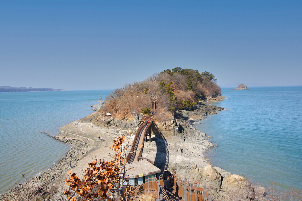
After about 50 minutes of walking on the hill road, I saw the arch of Ant’s Waist Bridge. This bridge connects Gubong Island with its uninhabited neighbor Gokkal Island.
Its presence allows hikers to travel to Gokkal even when the tide is high. When the waters recede, visitors can venture down below the bridge and walk along the gravel beach.
After you cross the bridge, the setting sun observatory is roughly a 10-minute walk away. The location affords a view of both Incheon Bridge and the Yellow Sea sunset.
At the center of the observatory is a work called “Keeping the Sunset in the Heart,” which artistically represents the setting sun and its colors. The sight of the setting sun framed by the rounded band and sunset-shaped structure is famous for its beauty. This place is considered the top spot for picture-taking on Daebu Island.
As you make your way back from the observatory, I recommend walking along the coast rather than through the hills. The typical course is to hike through the hills to visit the sunset observatory, and then to return along the coast after seeing the sun set over the ocean.
Of course, you can only follow the coastal role below the observatory when the tide is out. If you choose the right tide time, a walk along the coast is a chance to see the sea up close as it sparkles in the sun, while listening to the sounds of the waves and the gulls. It gives the sense of enjoying a work of art created by nature.
Also visible on the coastal route are Halmae (Old Woman) Rock and Harabae (Old Man) Rock, which are referred to collectively as the “Gubong menhirs.” The legend goes that after her husband went out to fish, the old woman waited so long that she turned into a rock; returning and finding her in that condition, the old husband turned into a rock himself. The large rocks offer their own spectacular sunset view.
Those visiting via public transportation can take the No. 123 bus toward Tan Island from the stations of Ansan and Oido along Line 4 of the Seoul Subway. From there, they can disembark at Bangameori Wharf or the last stop at Tando Harbor.
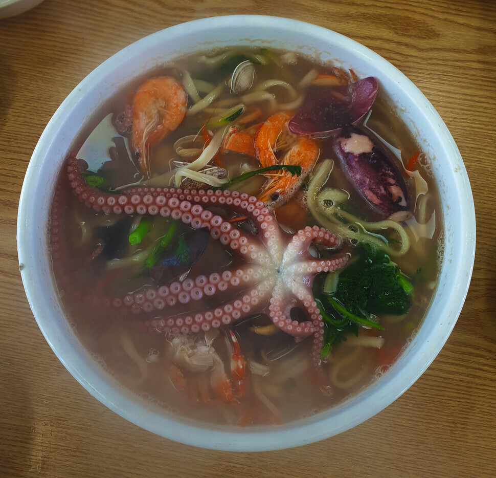
The premier dish on Daebu Island is kalguksu knife-cut noodles with bajirak short-necked clams or assorted seafood. Thanks to the fresh clams caught along the island’s fertile tidal flats, the noodle soup boasts an exquisitely rich and homey flavor. Restaurants specializing in kalguksu can be found all over the island.
Worthwhile stops: Daebu Island also has an arboretum with an ocean view. Known as the Badahyanggi Arboretum, it is located at 399 Daebuhwanggeum Road in Ansan’s Danwon District (031-8008-6795). It boasts a total area of 1.01 million square meters and some 1,000 varieties of coastal flora and other plants.
Other distinctive spots include the “Imagination Observatory,” where visitors can take in the Yellow Sea coast landscape of Nue, Jebu, and Keunhaem islands, and the eco-ponds of Bada Neourwon and Amseogwon. Admission and parking are free.
Near the harbor on Tan Island is the Ansan Fishing Village Folk Museum (7 Daebuhwanggeum Road, Danwon District, Ansan, 032-886-0126), which offers a glimpse at fishing lives and culture. It includes exhibits showing daily life for people in Daebu’s island villages, as well as various examples of organisms from the tidal flat ecosystem. It’s open from 9 am to 6 pm (closed Mondays). Admission is 2,000 won for adults.
By Her Yun-hee, staff reporter
Please direct questions or comments to [english@hani.co.kr]

Editorial・opinion
![[Editorial] Intensifying US-China rivalry means Seoul must address uncertainty with Beijing sooner than later](https://flexible.img.hani.co.kr/flexible/normal/500/300/imgdb/original/2024/0517/8117159322045222.jpg "[Editorial] Intensifying US-China rivalry means Seoul must address uncertainty with Beijing sooner than later") [Editorial] Intensifying US-China rivalry means Seoul must address uncertainty with Beijing sooner than later
[Editorial] Intensifying US-China rivalry means Seoul must address uncertainty with Beijing sooner than later![[Column] When ‘fairness’ means hate and violence](https://flexible.img.hani.co.kr/flexible/normal/500/300/imgdb/original/2024/0516/7417158465908824.jpg "[Column] When ‘fairness’ means hate and violence") [Column] When ‘fairness’ means hate and violence
[Column] When ‘fairness’ means hate and violence- [Editorial] Yoon must stop abusing authority to shield himself from investigation
- [Column] US troop withdrawal from Korea could be the Acheson Line all over
- [Column] How to win back readers who’ve turned to YouTube for news
- [Column] Welcome to the president’s pity party
- [Editorial] Korea must respond firmly to Japan’s attempt to usurp Line
- [Editorial] Transfers of prosecutors investigating Korea’s first lady send chilling message
- [Column] Will Seoul’s ties with Moscow really recover on their own?
- [Column] Samsung’s ‘lost decade’ and Lee Jae-yong’s mismatched chopsticks
Most viewed articles
- 1[Editorial] Transfers of prosecutors investigating Korea’s first lady send chilling message
- 2For new generation of Chinese artists, discontent is disobedience
- 3[Column] US troop withdrawal from Korea could be the Acheson Line all over
- 4[Exclusive] Unearthed memo suggests Gwangju Uprising missing may have been cremated
- 5[Editorial] Intensifying US-China rivalry means Seoul must address uncertainty with Beijing sooner t
- 6Xi, Putin ‘oppose acts of military intimidation’ against N. Korea by US in joint statement
- 7Celine Song says she’s gratified global audiences have responded to the kismet of ‘inyeon’
- 8Could Korea’s Naver lose control of Line to Japan?
- 9China, Russia put foot down on US moves in Asia, ratchet up solidarity with N. Korea
- 10Yoon ridicules critics of Fukushima dumping in first comments since release began